

|
|
|
|
Day 1 (09 April)
|
||||
|
|
||||
|
We set out very early, around 04:00 o’clock in the morning on April 9th, and after we drove some 380 kms we were at our hotel... “Kum Otel” (sand hotel) is practically the only one hotel that you can rest in the peninsula... it is at at Kum Limani (sand harbour) near Kabatepe harbour... Kabatepe is also at the west coast of the peninsula and you can find also a small museum there about the remainings of the war... the road around the museum at Kabatepe was so crowded that we could just make our way to pass the crowd and reach our hotel... many busses were there bloking the roads... plenty of students and citizens were there to visit the place which after so many years has become a sopopular place to go... but this resulted to plenty of garbage thrown around and so many new road constructions to accomodate the increasing number of visitors...
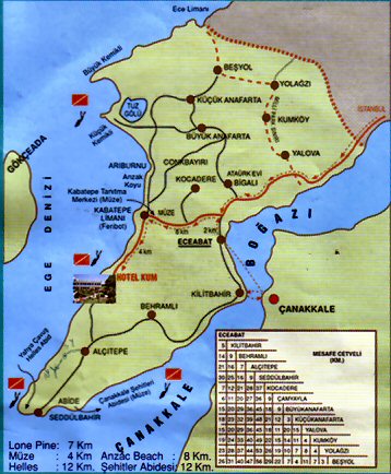
Here is a simple map of the peninsula scanned from a brochure of our hotel we stayed... to the left is the Eagean see and to the right is the Dardanelles or Canakkale strait that opens to the Marmara sea and than the Bosphorous strait and than the Black sea... As far as I know the allies where aiming of holding control of Istanbul and the straits to prevent Russia coming to the southern seas... on the map yo can see the salt lake and the Suvla bay, then if you follow to the south it is the ANZAC cove which was the place where ANZACs landed... that place is surroundedn by high hills where the Chunuk Bair is the topmost and was in control of the Turkish army... if you follow southwards you come to the shore that our hotel resides, and below that spot starts the place where the British landed... at the southern spot is the Helles monument, and then if you turn towards east and then north it is the place whee the French landed... Abide monument is here and then the strait starts... the narrower place is Kilitbahir and that was the places Turkish army hold control and the allies were not able to cross so they decided to land and fight... To the left of the peninsula you can see Gokceada island (Imbros in Greek)... one of the two islands that belong to Turkey... this is a very beautiful island and there is still a small greek community but most of the greek villages are deserted... |
||||
 |
||||
|
After we got the keys and checked our room we left the hotel and started our excursion... we drove southwards and came to Alcitepe village (the old Kirene or Ahci Baba village as it was called by the foreign armies)... we turned to the west and driving thru Sargiyeri (or Zigindere) we went up to “Nuri Yamut” monument... this monument was built in 1943 and the bones of the dead soldiers found around at Sargiyeri were placed here... Note. In the following pages you may click on the thumbnail images to view them in full size |